Table of Contents
- 1. The Oceanic Threshold: Understanding the Tidal Clock at Tanah Lot
- 2. Calcarenite and Basalt: The Wave-Cut Shore Platform
- 3. The Paradox of Tirta Pabersihan: Subterranean Freshwater in the Sea
- 4. Etiquette and the Mangku’s Purificatory Blessing
- 5. Astronomical Tide Tables and Safety Logistics
- 6. Verified Sources & Scholarly References
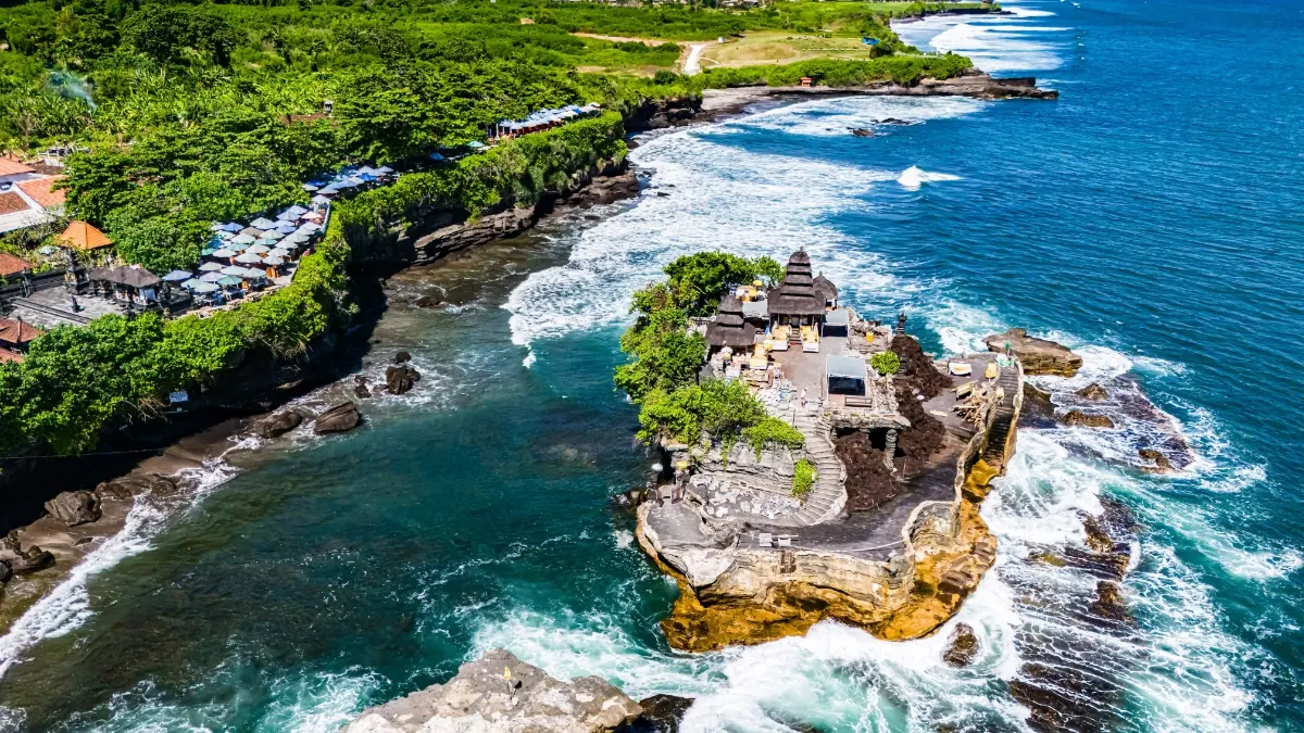
Twice each lunar day, the roaring Indian Ocean recedes from the southwestern coast of Tabanan Regency, transforming Pura Tanah Lot from an impregnable sea citadel into an accessible geological headland. While thousands of evening sightseers crowd the clifftop terraces to capture sunset silhouettes, the true sensory heart of Tanah Lot lies below—on the slippery, wave-carved calcarenite reef exposed only at low tide. Walking this intertidal corridor reveals one of the most hydrogeologically astonishing sacred features in the Indonesian archipelago: a roaring freshwater fountain bubbling up from the ocean floor directly beneath a sanctuary battered by brine.
Before embarking on your coastal exploration, verify your regulatory arrival fees and currency conversions through the official Bali Tourist Levy & Entry Requirements Calculator, ensuring your documentation is fully compliant with regional heritage preservation standards.
1. The Oceanic Threshold: Understanding the Tidal Clock at Tanah Lot
The name Tanah Lot derives etymologically from the Balinese words Tanah (earth or land) and Lot (ocean or sea), translating literally as "Ancient Islet in the Middle of the Sea." This nomenclature captures the temple’s dual geographical state. At high tide, oceanic swells generated in the Southern Ocean strike the basaltic perimeter, cutting off pedestrian access entirely and engulfing the tidal flat under up to 2.5 meters of churning surf.
During the astronomical low-tide window—defined by Indonesian hydrographic data as sea levels falling below 0.6 meters above lowest astronomical tide (LAT)—the ocean withdraws over eighty meters seaward. The seabed transforms into a sprawling platform of wet volcanic sandstone, pitted limestone hollows, and miniature tidal pools harboring green macro-algae (Ulva lactuca) and fragile benthic marine organisms. It is during this precise window that Balinese devotees and respectful travelers can walk directly to the cavernous base of the sacred offshore monolith.
2. Calcarenite and Basalt: The Wave-Cut Shore Platform
The landform supporting Pura Tanah Lot is not an artificial breakwater, but an erosional relict of the Southern Bali Neogene Sedimentary Formation. According to stratigraphical surveys conducted by the Geological Agency of Indonesia (Badan Geologi), the rock foundation consists of layered calcarenite, volcanic breccia, and tuffaceous sandstone deposited during the late Miocene to early Pliocene epochs.
Hydrodynamic Forces at Work
Continuous hydraulic wedging, wave cavitation, and salt weathering naturally carved the surrounding shoreline, detaching the temple islet from the mainland headland over several millennia. The flat surface you walk upon is a classical wave-cut shore platform, preserved through equilibrium between tectonic uplift and maritime abrasional wear.
Walking across this platform requires careful foot placement. The surface features deep surge fissures (known locally as selat) where receding waves accelerate with dangerous velocity. Wearing marine reef-shoes with vulcanized rubber grip is strongly advised by Tabanan coastal rescue officers (Balawista), as bare feet or smooth flip-flops easily lose traction on marine slickensides.
3. The Paradox of Tirta Pabersihan: Subterranean Freshwater in the Sea
Nestled directly inside an undercut sea cave on the eastern flank of the monolith lies Tanah Lot’s greatest natural and theological mystery: Tirta Pabersihan (The Holy Purifying Water). Here, mere paces away from the crashing salty waves of the Indian Ocean, a continuous, crystal-clear stream of completely fresh, potable drinking water bubbles vigorously out of the solid stone floor.
| Hydrogeological Metric | Tirta Pabersihan (Spring) | Surrounding Sea Water |
|---|---|---|
| Salinity Level | < 0.05% (Freshwater Potable) | 3.4% – 3.6% (Full Oceanic Brine) |
| Water Source Mechanism | Confined Artemian Volcanic Aquifer from Mt. Batukaru | Indian Ocean Southern Equatorial Current |
| Spiritual Function | Tirta Pemarisuda (Purification of Mind & Body) | Segara (Cosmic Dissolution / Pradaksina) |
Hydrogeologists from Udayana University attribute this phenomenon to a coastal artesian aquifer. Rainfall originating high on the volcanic slopes of Mount Batukaru percolates deep through porous andesitic strata, traveling under immense gravitational pressure beneath Tabanan’s southern plains. When the impermeable marine shale formation meets an oceanic fault line at Tanah Lot, the pressurized freshwater fractures the rock ceiling, venting out as an offshore submarine spring.
4. Etiquette and the Mangku’s Purificatory Blessing
For Balinese Hindus, Tirta Pabersihan is not merely a geological curiosity; it is a vital sacrament. Stationed at the entrance of the natural cavern, traditional Balinese priests (Pemangku) clad in white ceremonial robes receive pilgrims seeking ritual cleansing. Foreign visitors who demonstrate respect and appropriate modesty are welcome to receive the blessing.
- The Washing Rite (Kukus/Kecup): The Pemangku will pour cool, sweet freshwater into your cupped palms. You drink a small sip three times, wash your face three times, and splash your head to cleanse your thoughts (Manacika), speech (Wacika), and actions (Kayika).
- Bija Placement: The priest presses wet grains of raw white rice (Bija or Wija) onto the center of your forehead (the third eye, symbolizing divine perception) and onto your collarbone.
- The Fragrant Blossom: A fresh yellow marigold (Gemitir) or frangipani (Jepun) blossom is tucked behind your right ear, representing the fragrant elevation of the spirit.
- Sasari Offering: A modest voluntary donation (typically IDR 10,000 to 20,000) placed in the offering basket (Sesari) supports the daily maintenance of the holy cavern and ceremonial upkeep.
5. Astronomical Tide Tables and Safety Logistics
Planning a low-tide reef excursion requires cross-referencing reliable marine forecasting data rather than relying solely on general weather apps. The tide times at Tanah Lot shift by approximately 50 minutes each solar day due to the lunar orbital progression.
- Consult the Benoa/Canggu Marine Chart: Verify predicted low tide using the Indonesian National Institute of Hydrography and Oceanography (Pushidrosal) or maritime forecasting platforms (such as Magicseaweed or Windguru) calibrated to the southwestern Bali coastline.
- Arrive 45 Minutes Before Dead Low: Entering the reef as the tide ebbs ensures the safest walking conditions and provides ample time to receive the blessing before water levels begin their swift return.
- Listen to the Balawista Whistles: When the tide turns, ocean currents reverse rapidly. If you hear the Tabanan Lifeguard unit sounding high-pitched whistles, immediately exit the reef bed and return to the paved headland.
6. Verified Sources & Scholarly References
- Balai Pelestarian Kebudayaan (BPK) Wilayah XV Bali-NTB: Kajian Konservasi Kawasan Cagar Budaya Pura Tanah Lot Tabanan (2021).
- Badan Geologi, Kementerian ESDM RI: Peta Geologi Lembar Bali dan Struktur Neogen Pantai Selatan (Bandung: Pusat Survei Geologi).
- Udayana University Faculty of Mathematics and Natural Sciences: Hydrogeological Profile of Coastal Submarine Springs in Southern Tabanan (Journal of Marine Science & Technology, 2023).
- Dinas Kebudayaan Kabupaten Tabanan: Babad Dang Hyang Dwijendra dan Sejarah Pura Segara Tabanan (Denpasar: Percetakan Manik Halim).